IDAHO COUNTY (A -L)
ANDERSON BUTTENez Perce National Forest - 29N-9E-3
|

|
ANT HILL
Clearwater National Forest - 35N-8E-29
|

|
ARCHER POINTNez Perce National Forest - 30N-13E-20
|

|
ARCTIC POINTPayette National Forest - 25N-12E-30
|

|
*AUSTIN RIDGE
Clearwater National Forest - 35N-6E-26
|

|
BAD LUCK POINTBitterroot National Forest - 30N-14E-33
|

|
BAILEY MOUNTAINNez Perce National Forest - 34N-13E-30
|

|
BALD MOUNTAIN
Clearwater National Forest - 36N-10E-20
|

|
BALLY MOUNTAINPayette National Forest - 21N-2E-31
|

|
BARREN HILLNez Perce National Forest - 34N-12E-29
|

|
BAT POINTNez Perce National Forest - 26N-10E-19
|

|
BATTLE CREEKNez Perce National Forest - 33N-14E-10
|

|
BEAR MOUNTAIN (BEARGRASS MOUNTAIN)Clearwater National Forest - 36N-12E-26
|

|
BEAR PETE MOUNTAINPayette National Forest - 22N-4E-4
|

|
BEAR POINTNez Perce National Forest - 26N-11E-36
|

|
BEAR WALLOWNez Perce National Forest - 32N-11E-11
|

|
BEARGRASSNez Perce National Forest - 31N-8E-21
|

|
BEAVER JACKBitterroot National Forest - 28N-14E-23
|

|
BEAVER RIDGEClearwater National Forest - 37N-17E-10
|

|
BELL POINTNez Perce National Forest - 33N-14E-5
|

|
BEMIS POINTPayette National Forest - 23N-7E-31
|

|
BIG BURN POINTNez Perce National Forest - 30N-5E-33
|

|
BIG CREEK (PATROL LO)Nez Perce National Forest
|

|
BIG CREEK POINTNez Perce National Forest - 33N-15E-28
|

|
BIG HILL Clearwater National Forest - 33N-7E-31
|

|
BIG HILLPayette National Forest - 21N-14E-20
|

|
BIG ROCK (62)Nez Perce National Forest - 33N-11E-14
|

|
BIG SAND
National Forest - 34N-15E-15
BLACK BUTTENez Perce National Forest - 25N-5E-20
|

|
BLACKHAWK MOUNTAINNez Perce National Forest - 29N-10E-31
|

|
BLACKTAIL (FRISCO PEAK)Nez Perce National Forest - 33N-11E-9
|

|
BLACKTAIL BUTTENez Perce National Forest - 30N-4E-31
|

|
BLUE JOINTNez Perce National Forest - 26N-15E-26
|

|
BOSTON MOUNTAIN
Nez Perce National Forest - 27N-10E-26
1920's: A crow's nest established.
c.1931: A 60-foot round native pole tower with an L-6 cab constructed. Also a log living quarters cabin built.
1958: The lookout structure destroyed.

BOUNDARY PEAK
Clearwater National Forest - 35N-7E-13
1981: "The point was first manned in 1933 with the lookout quartered in a tent camp. The point was manned each season thereafter until 1951.
In 1934, Rufus Robinson with unknown helpers, under the direction of District Ranger Roy Lewis, built a 20' high log tower with an L-4 cabin. Construction cost was $488.00.
The tower was left in place until 1954 and was condemned and burned after all above ground lightning protection material was salvaged." (Louis Hartig, 'Historic Facilities of the Lochsa Ranger District' - 1981)

BOUNDARY POINT
Nez Perce National Forest - 27N-6E-29
1937: A camp established.
1941: The camp abandoned.

BOX CANYON
Payette National Forest - 23N-2E-2
c.1930: crow's-nest

BOX CAR MOUNTAIN
Nez Perce National Forest - 30N-12E-21
1928: A camp established.
1939: The camp dismantled.

BRUSH HILL TREES
Clearwater National Forest - 34N-7E-21

BUCKTAIL BUTTE

BUFFALO HUMP
Nez Perce National Forest - 26N-6E-3
|

|
BURGDORF SUMMIT
Payette National Forest - 23N-7E-21
1920's; crow's-nest

BURNT KNOBPayette National Forest - 25N-10E-31
|

|
BURNT KNOBNez Perce - Bitterroot National Forest - 27N-12E-5
|

|
BURNT STRIP MOUNTAIN
Bitterroot National Forest - 29N-15E-19
c.1939: cabin
c.1955: Destroyed

BURPEE MOUNTAIN
Nez Perce National Forest - 26N-8E-17
c.1930: A log cabin built.
1940: The site abandoned.

BUTTS CREEK POINT
Salmon National Forest - 23N-14E-4
|

|

CALIFORNIA POINT
Clearwater National Forest - 35N-12E-32
1981: "This point was manned only during the summer of 1939 with the lookout living in a tent camp. To get a better view of the surrounding terrain, a platform was rigged about 25 feet off the ground in a green tree with the tree top projected through it. There was no map-stand on the platform.
For communication, two miles of number nine, galvanized iron wire was strung up a ridge from the Fish Lake-McConnell Mountain telephone line and hooked to an iron telephone hung on a tree by the tent." (Louis Hartig, 'Historic Facilities of the Lochsa Ranger District' - 1981)

CANTALOUPE PEAK
Clearwater National Forest - 34N-9E-11
1934: camp
1942: Abandoned

*CAREY DOME
Payette National Forest - 24N-4E-24
|

|

*CASTLE BUTTE
Clearwater National Forest - 36N-10E-28
|
August 16, 2011 - Ron Kemnow photo
|
1981: "The point was first occupied as a full time seasonal lookout in 1914 when Middlefork District Ranger Joseph McGhee sent Wolford Renshaw and his brother Hubert, with their horses and camp outfit, from Number one R.S. to man the peak as lookout and smokechaser.
In 1915 Castle Butte smokechasers Wolford Renshaw and Shelton McPherson cut and peeled logs for cabin sills at Castle. In 1916 the lumber stored at Bald Mtn. was packed over and a cabin was built on the rock capped peak. Though crude by later standards, this was the first observatory on the Fish Lake District and it did have windows on all sides so employees dubbed it "The House of Glass". The cabin was in use until 1929 when it was replaced by the more up-to-date L-3 log lookout cabin with a cupola for the firefinder and observer.
Harry Chenoweth and Russell Stadtman dismantled the "House of Glass" in 1929 and in its stead built a new L-3 type cabin. The L-3 was designed with a lower room about twelve feet square which was used for living quarters. The fire-finder was housed in a five or six foot square, glass-enclosed observatory that projected through the roof. The lower walls of this cabin were built of logs cut a year earlier; gable ends, roof and cupola were built of lumber covered with shingles or shakes.
The cabin was used each summer until 1950 when it was replaced by an L-4 type structure.
In August of 1950, Howard Beebe, a carpenter from Weippe, with guard Bill O'Brien and one or two other helpers began work on the new lookout cabin. It was erected on a 7' high understory of the stone that is so abundant on the peak. The cabin was one of the several that had been pre-cut at the Pierce carpenter shop during the previous winter. To make the building more sturdy, all lumber, including catwalk railings, were cut full length. There was no splicing as in some of the earlier pack-in-type cabins.
It was built along side the old cabin which was used as crew quarters until the new one was ready for occupancy. Construction cost was $1711.00. Logs salvaged from the old cabin were, over a period of years, sawed up for wood to stoke the lookout's cook stove. Some time around 1970 the lookout was abandoned." (Louis Hartig, 'Historic Facilities of the Lochsa Ranger District' - 1981)

CEDAR KNOBClearwater National Forest - 34N-7E-27
|

|
CHAIR POINTNez Perce National Forest - 25N-2E-28
|

|

CHICKEN PEAKPayette National Forest - 23N-9E-31
|

|

CLEAR CREEK
Nez Perce National Forest - 31N-6E-32
1931: 20-foot tower with L-4 cab.
1949: Abandoned

COLD MOUNTAINPayette National Forest - 22N-12E-14
|

|
COLD SPRINGS
Nez Perce National Forest - 25N-1W-15
1930: log cabin
1958: 41-foot treated timber tower with R-6 cab.
1979: Destroyed

COLUMBIA RIDGE
Nez Perce National Forest - 27N-7E-33
c.1933: 50-foot pole tower with L-4 cab.
1963: Destroyed

CONCORD
National Forest - 26N-7E-18
c.1930: camp

COOLWATERClearwater National Forest - 33N-8E-33
|

|

COOPER POINT
Bitterroot National Forest - 29N-15E-26
1930's: camp

COOPERATION POINT
Clearwater National Forest - 36N-13E-27
1934: pole tower with L-4 cab
1950: Destroyed

CORRAL HILLNez Perce National Forest - 30N-5E-3
|

|
1929: 40-foot tower
1953: 41-foot treated timber tower with an L-4 cab.

COTTONTAIL POINT
Payette National Forest - 24N-6E-32
1934: 72-foot steel tower.

COTTONWOOD
Private - 30N-3W-23
1929: log cabin with roof platform.
1965: Destroyed
COTTONWOOD BUTTEIdaho Department of Lands 32N-1W-33
|

|
COTTONWOOD BUTTE
Payette National Forest - 23N-14E-31
|

|
CRANE HILL
Nez Perce National Forest - 31N-5E-2
c.1933: 30-foot tower with L-4 cab.
1954: Destroyed

CROFOOT POINT (PATROL LO)
Nez Perce National Forest
CROSS TRAILS
Nez Perce National Forest - 25N-6E-26
CUB POINTBitterroot National Forest - 31N-14E-25
|

|
DAIRY MOUNTAIN
Nez Perce National Forest - 27N-3E-17
1927: 75-foot crow's-nest
1945: 45-foot pole tower with L-4 cab
1960: Destroyed

DAN RIDGE
Clearwater National Forest - 36N-17E-9
1934: 30-foot pole tower with L-4 cab.
1973: Destroyed

DEAD ELK POINT
Nez Perce National Forest - 34N-15E-25
1930's: camp

DENNIS MOUNTAIN
Bitterroot National Forest - 26N-12E-26
1930: camp

DENT POINT
Nez Perce National Forest - 30N-9E-26
c.1933: tower with L-4 cab.
1950: Abandoned

DIABLO MOUNTAINClearwater National Forest - 34N-15E-7
|

|
DISGRACE BUTTENez Perce National Forest - 30N-10E-26
|

|
1935: 30-foot tower with L-4 cab
1950: Abandoned

DOE POINT
Clearwater National Forest - 34N-11E-36
c.1930: camp
1981: "Doe Point was an overload or emergency lookout. Each Ranger District had a number of such lookouts in the fire plan as determined by elapsed travel time, fuel types and seen area. The points were to be manned when fire danger reached a predetermined critical stage. Actual manning was usually left to the discretion of the District Ranger. Evidently it was expected that Doe Point would be manned rather frequently as a telephone line was extended there from Rhoda Point in 1938 or '39. As it turned out the point was manned only one or two seasons between 1938 and '41, and then abandoned. Since the lookout man stayed in a tent camp there was not much to abandon." (Louis Hartig, 'Historic Facilities of the Lochsa Ranger District' - 1981)

DOG POINT
Nez Perce National Forest - 32N-13E-22
1937: log cabin
1939: Abandoned

DOME HILL
Nez Perce National Forest - 27N-5E-17
c.1938: camp
1942: Abandoned

DOUBLE CREEK RIDGENez Perce National Forest - 33N-13E-2
|

|
DRY DIGGINSNez Perce National Forest - 24N-2W-33
|

|

DRY POINT
Clearwater National Forest - 33N-7E-2
1981: "The date of construction of this tower has not been determined. The structure consisted of an L-4 cabin on a 20-foot-high log tower built at a cost of $1113.00. It is also not known when the place was last manned. It was not manned in 1956. The tower and cabin were burned in 1963." (Louis Hartig, 'Historic Facilities of the Lochsa Ranger District' - 1981)

EAGLE CREEK POINT
National Forest - 29N-13E-8
c.1933: camp
1951: Abandoned

EAGLE MOUNTAIN
Clearwater National Forest - 35N-11E-32
1981: "1915 was the first year that Eagle Mtn. was manned as a regular season lookout. Sometime in July, Sam Weholt and Al Peterson were set up for business in a tent camp near the observation point.
At Eagle Mtn. the two men installed a post in the rocks on top of the peak on which they mounted their Koch baseboard and map. Communication with Castle Butte was established sometime in August. The telephone line was number nine galvanized iron wire from Castle Butte to the Lochsa River and emergency wire from there to Eagle.
As far as is known, this lookout was manned each season, using tent quarters, until 1920. Since there were no improvements at the point, abandonment consisted of loading the camp on a pack string and pulling out.
The Mountain was again used in 1922 when smokechaser Jess Mosher, camped at End Butte and made scheduled foot patrols out to Eagle Mtn. to scan the country for smoke from this vantage point." (Louis Hartig, 'Historic Facilities of the Lochsa Ranger District' - 1981)


ELK BUTTE
National Forest - 25N-5E-13
1930's: camp

ELK CITY
Nez Perce National Forest - 29N-8E-25
c.1930: tower with L-4 cab
1942: Abandoned

ELK RIDGE
Nez Perce National Forest - 32N-15E-31
1935: camp
1942: Abandoned

ELK SUMMIT
Clearwater National Forest - 35N-14E-36
1924: cupola cabin

ELK SUMMITNez Perce National Forest - 29N-7E-1
|

|

ELKHORN MOUNTAIN
Bitterroot National Forest - 25N-13E-29
1933: L-4 cab
July 12, 1958: "Two men waiting in the woods with a damaged helicopter will have to spend another day there because the parts needed to repair the craft didn't arrive in Missoula Friday in time to be shipped to them.
The helicopter was disabled Wednesday in landing at Elkhorn Point lookout in the Selway-Bitterroot primitive area north of the Salmon River breaks in Idaho.
The trip to them will be made Saturday with another helicopter carrying blades for the rear rotor and a rotor shaft along with a mechanic.
The two men are Stan Greenup, a Bitterroot National Forest Employe, and Fred Gerlach of Missoula, pilot who flew Greenup to the lookout to prepare it for summer use." (Billings Gazette)
1959: R-6 cab atop a 10-foot concrete base.
1991: Destroyed

END BUTTE
Nez Perce National Forest - 34N-11E-8
1922: Established as an observation point with a tent camp.
1939: A ten-foot log tower with a L-4 cab was erected.

1955 or 6: Lookout was condemned and burned.
1981: "End Butte was first used as an observation point in 1922 when Fish Lake District Ranger Al Kolmorgan set a tent camp in a little meadow at the head of Wounded Doe Creek about 3/4 mile from the top of the Butte. Scheduled patrols were made to End Butte and out the ridge to Eagle Mtn. Telephone communication with Boulder Creek R.S. via an emergency wire line tied into the emergency line which at that time connected Stanley Butte to the iron wire line at Fish Lake Saddle.
End Butte was not manned again until 13 years later. During the 1935 season a lookout with tent quarters was placed near the top of the Butte and a galvanized iron wire telephone line was built in from Fish Lake Saddle. The tent camp was used each summer through 1939, when at a cost of $1224.00, Ranger Hans Roeffler had material packed in and built an L-4 lookout cabin on a 10' log tower in the rocks on the top of the peak. The tower was manned seasonally through 1952, at which time aerial detection made the structure obsolete. It was condemned and burned in 1955 or 1956." (Louis Hartig, 'Historic Facilities of the Lochsa Ranger District' - 1981)
End Butte was not manned again until 13 years later. During the 1935 season a lookout with tent quarters was placed near the top of the Butte and a galvanized iron wire telephone line was built in from Fish Lake Saddle. The tent camp was used each summer through 1939, when at a cost of $1224.00, Ranger Hans Roeffler had material packed in and built an L-4 lookout cabin on a 10' log tower in the rocks on the top of the peak. The tower was manned seasonally through 1952, at which time aerial detection made the structure obsolete. It was condemned and burned in 1955 or 1956." (Louis Hartig, 'Historic Facilities of the Lochsa Ranger District' - 1981)

FALL CREEK POINT
Nez Perce National Forest - 29N-6E-25
c.1930: Two-story log cabin with cupola.
1950: Abandoned

FALLS POINTNez Perce National Forest - 31N-9E-9
|
|

FAWN RIDGE
Bitterroot National Forest - 24N-13E-10
c.1939: camp

FIRE CREEK POINT
Clearwater National Forest - 33N-9E-29
1930's: camp

FIRE MOUNTAIN
Bitterroot National Forest - 29N-13E-35
1930's: camp

FISH BUTTEClearwater National Forest - 35N-8E-36
|
|
FISH CREEKNez Perce National Forest - 29N-3E-15
|
|
FOG MOUNTAINNez Perce National Forest - 32N-10E-20
|

|

FREE USE POINT
Nez Perce National Forest - 28N-2E-24
1931: 20-foot pole tower with L-4 cab.
1953: Destroyed

FREEMAN PEAKNez Perce National Forest - 32N-13E-1
|

|

FRENCHMAN BUTTE
Clearwater National Forest - 34N-7E-2
1933: 50-foot tower with L-4 cab.
1981: "In 1933 Earnest Hartman and Richard Stadtman built an L-4 cabin on a 50' tower at a cost of $915. The structure was used seasonally until the late 1940's or early 1950's, then dropped from the fire plan.
By 1960 the stairway had become hazardous to climb so the tower was tumbled to the ground and burned after lightning protection fixtures has been salvaged. A garage built at the lookout in 1936 was burned in about 1958." (Louis Hartig, 'Historic Facilities of the Lochsa Ranger District' - 1981)
By 1960 the stairway had become hazardous to climb so the tower was tumbled to the ground and burned after lightning protection fixtures has been salvaged. A garage built at the lookout in 1936 was burned in about 1958." (Louis Hartig, 'Historic Facilities of the Lochsa Ranger District' - 1981)
c.1960: The tower was toppled and burned.

GARDINER PEAKNez Perce National Forest - 30N-14E-6
|
|

GATEWAY PEAK
Nez Perce National Forest - 34N-14E-25
c.1926: camp
1939: Abandoned

GEDNEY MOUNTAIN
Nez Perce National Forest - 33N-10E-31
1934: cabin
1934: Burned in wildfire.

GLENWOOD TREE
Clearwater Timber Protective Association - 33N-5E-2

GODDARD POINT
Nez Perce National Forest - 31N-7E-9
1930's: camp

GOLD HILL
Clearwater National Forest - 35N-10E-28
1931: A 30-foot round timber tower with a L-4 cab was built.

1954: The tower was cut down and later burned.
1981: "The point was manned for the first time in 1931 and that same year Earnest Hartman and Harry Chenoweth were moved to Gold Hill under the direction of Ranger Fred Shaner and there they built a 30' high log tower on top of which they assembled a pre-cut L-4 lookout cabin. Material for the cabin was packed in from roads end at Bimerick Creek by mule train and as in all cases of offroad tower construction, sand, gravel and cement for the concrete piers on which the four tower legs were to set and anchored, was also moved in by pack string. Sand and gravel were available on the Lochsa River, near the station. When the tower and cabin were completed, the lookout man moved in and, with very few exceptions, the point was manned each season until 1951.
In 1954 Assistant Ranger Charles Smith sawed two legs off the tower and dumped it on the ground where it was later burned. Only the completely barren hill on which the tower was located saved it from being burned in the 1934 fire." (Louis Hartig. 'Historic Facilities of the Lochsa Ranger District' - 1981)
In 1954 Assistant Ranger Charles Smith sawed two legs off the tower and dumped it on the ground where it was later burned. Only the completely barren hill on which the tower was located saved it from being burned in the 1934 fire." (Louis Hartig. 'Historic Facilities of the Lochsa Ranger District' - 1981)

GOLD MEADOWS
Clearwater National Forest - 35N-11E-16
1981: "In 1937 lookout-fireman Lester Felton was set up for business in a tent camp at the Gold Meadows observation point on the ridge top. Trail #206 passed right by his camp, as did the telephone line. Les with a helper built a small log cabin at the point. It was about 8' x 10' in size and when finished was used for sleeping quarters and supply storage, cooking was done in the tent set up in front of the cabin. The set up at this location didn't last long. It may have been manned one more year, but by 1939 the observer had been moved to Sponge Mtn. about two miles to the south but still on Trail #206." (Louis Hartig, 'Historic Facilities of the Lochsa Ranger District' - 1981)

GOOSE CREEK POINT (PATROL LO)
Nez Perce National Forest

GRANITE PEAKNez Perce National Forest - 29N-11E-10
|
|
c.1934: camp
1939: Abandoned

GRASS MOUNTAINPayette National Forest - 24N-12E-26
|
|
1920's: tent camp
1934: L-4 cab
1978: Destroyed

GRAVE BUTTEClearwater National Forest - 36N-11E-17
|
|
GRAVE MEADOWNez Perce National Forest - 30N-11E-3
|
|
1939: camp

GRAVE PEAKClearwater National Forest - 35N-15E-8
|

|
GRAVE POINTNez Perce National Forest - 27N-1E-30
|
|
*GREEN CREEK POINT
Nez Perce National Forest - 30N-5E-6
|
|
|
no date - National Archives, Seattle
1931: 100-foot steel tower erected. |

GREEN MOUNTAINNez Perce National Forest - 28N-11E-15
|
|
GREEN RIDGE (PATROL LO)Clearwater National Forest
|
|

GROUSE CREEK POINT
Nez Perce National Forest - 27N-11N-16
1930's: camp

GROUSE POINT
Clearwater National Forest - 35N-9E-9
1934: A 30-foot round timber tower with a L-4 cab was erected.
August 1934: The lookout was destroyed in the Pete King fire. The site was not used again.
.
1981: Grouse Point was manned for the first time in 1933 when a tent camp was set up with Russell Stadtman as lookout man. Slim Tunstill was sent up as carpenter foreman to build a 30' log tower and L-4 cabin. Stadtman and two other men helped with construction which was completed that year. In 1934, the tower was manned for the first and last time. In August of 1934 fire burned it to the ground. The point was never manned again." (Louis Hartig, 'Historic Facilities of the Lochsa Ranger District' - 1981)

GROUSE RIDGE
Nez Perce National Forest - 29N-12E-2
1926: crow's-nest
1928: log cabin with cupola.
c.1950: Destroyed

HANOVER MOUNTAIN
Nez Perce National Forest - 26N-4E-34
1931: smokechasers cabin????

HARD BUTTEPayette National Forest - 22N-2E-9
|
|
HEAVENS GATENez Perce National Forest - 23N-1W-5
|
|
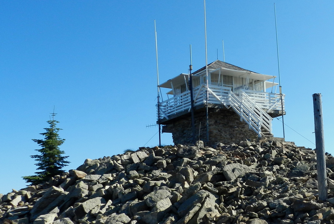
*HELLS HALF ACRE MOUNTAIN
Bitterroot National Forest
|
no date - USFS photo
|
August 11, 2012 - Ron Kemnow photo
|

1930: 40-foot tree platform
1940: 40-foot pole tower with L-4 cab.
1960: R-6 cab atop a 10-foot cinder block first floor.
July 26, 2013: The lookout structure was wrapped in a fire retardant material as a precaution to an oncoming wildfire threat. The lookout staff were temporarily moved to Salmon Mountain.


HIDA POINTPayette National Forest - 25N-10E-10
|

|

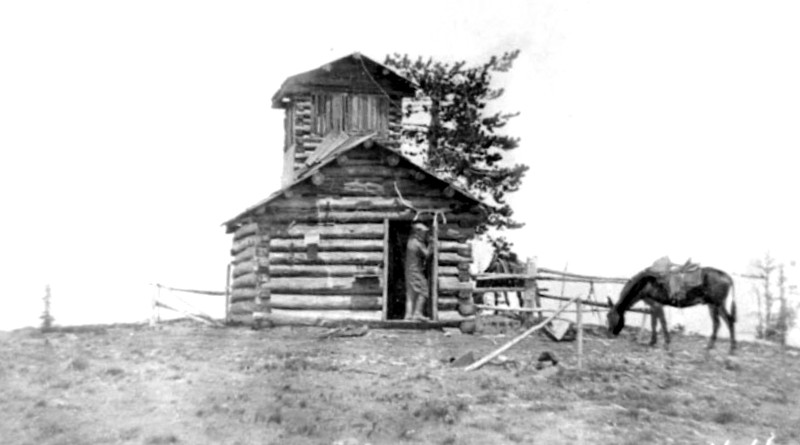
*HIDDEN PEAK
Clearwater National Forest - 35N-17E-16
|
1930 - Powell Ranger District collection (lookout under construction)
|
1927: 16x16 shake cabin
1930: A L-4 cabin was constructed atop six foot high log cribbing.
1961: R-6 cab atop a 10-foot concrete base.

HIGGINS HUMP
Clearwater National Forest - 33N-6E-13

HIGH SPRING
Nez Perce National Forest - 33N-11E-23
|

|

HIGHLINENez Perce National Forest - 31N-11E-18
|
|
1932: 35-foot platform tower with a two-story log cabin.

HORSE HEAVEN
National Forest - 22N-2W-3
1929: log cabin
1931: 30-foot pole tower with 7x7 cab
1950: Destroyed

HORSE POINTNez Perce National Forest - 31N-9E-34
|
|
1938: 30-foot tower with L-4 cab.
1950: Abandoned

HORSEFLY POINT
National Forest - 32N-14E-8
c.1938: camp

HOT POINT
Nez Perce National Forest - 32N-7E-20
1933: 30-foot tower with L-4 cab.
1957: Destroyed

HOT SPRINGS POINT
Clearwater National Forest - 36N-13E-9
1929: cabin
1956: Destroyed

HUNGRY CREEK POINT
Payette National Forest - 23N-13E-9
1935: camp

HUNGRY POINT
Clearwater National Forest

IDAHO POINT
Clearwater National Forest - 33N-8E-31
1930: 35-foot platform
1932: L-4 cab on a log crib.
1934: The lookout was destroyed in the Pete King fire.
INDIAN GRAVE
Clearwater National Forest - 37N-10E-36
1981: An L-4 cabin was constructed on a 50-foot tower in 1955 by the Lolo National Forest at a cost of $4234.00, this replaced an earlier structure (erected sometime prior to 1939). For an unexplained reason the tower was transferred from the Powell District of the Lolo National Forest to the Lochsa District sometime after 1956. In 1963 the Powell Ranger District was transferred to the Clearwater National Forest from the Lolo National Forest and the lookout was given back to the Powell District, near this time the tower was condemned and burned. (Louis Hartig, 'Historic Facilities of the Lochsa Ranger District' - 1981)
INDIAN HILLNez Perce National Forest - 31N-10E-29
|

|
INDIAN POST OFFICEClearwater National Forest - 37N-12E-19
|

|
INDIAN RIDGE (PETTIBONE)Nez Perce National Forest - 31N-14E-6
|

|

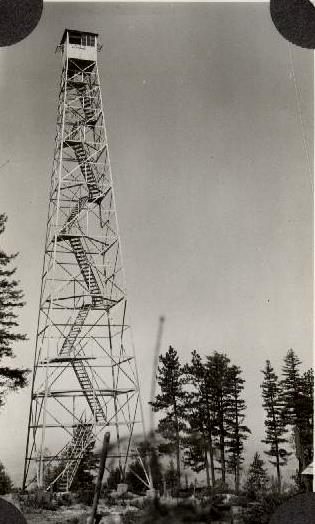
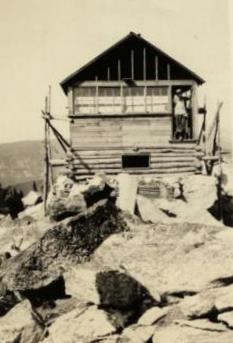
*IRON MOUNTAIN
Nez Perce National Forest - 30N-7E-20
|
1919 - G.V. Ring photo, U.S. Forest Service
|
1923: log cabin
1942: Abandoned

JACK MOUNTAIN
Nez Perce National Forest - 27N-9E-31
1931: 90-foot steel tower.
1953: 100-foot steel tower

JAY POINTClearwater National Forest - 36N-15E-5
|

|
JEANETTE (PATROL LO)Clearwater National Forest
|
|
JERRY JOHNSONLolo > Clearwater National Forest 36N-12E-3
|

|
JERSEY MOUNTAINNez Perce National Forest - 25N-7E-23
|
|
1931: log cabin with cupola (Kresek)
1953: 41-foot treated timber tower with L-4 cab. (Kresek)
1992: Burned in wildfire.
September 13, 1992: "In reference to Sandra Lee's 'Up Front' in the Sept. 2 issue of the Lewiston Morning Tribune, the Jersey Mountain lookout cabin was built in 1934 by Howard Higgins, who later became ranger of the Dixie District on the Nez Perce National Forest.
The lookout cabin sat well above the timberline on the rocky knoll of Jersey Mountain. The tower was not constructed until the late 1950s because the trees began to grow up the slope of the mountain making the cabin and its lookout cupola ineffective.
My husband, Dr. Fred Brown, was employed by the Dixie Ranger District during the summers of 1942, '46, '47, '48 and '49 on trail and telephone maintenance and as lookout on Jersey Mountain. I joined him there for the summers of 1948 and '49 after we were married. The road was built to the lookout in the spring of 1949. Prior to that time supplies were packed in by pack string and water backpacked a little over a half mile from a spring south of the lookout.
All of us who treasure memories of Jersey Mountain Lookout were saddened by the loss of this historic facility. LOLITA BROWN" (Lewiston Morning Tribune)
JOHN DAY MOUNTAINNez Perce National Forest - 25N-2E-5
|

|

JUNGLE POINT
Nez Perce National Forest - 28N-3E-27
1930: camp (Kresek)
1942: Abandoned (Kresek)

KELLY MOUNTAIN
Nez Perce National Forest - 24N-3E-17
1930: 100-foot tree platform (Kresek)
1938: 40-foot pole tower with L-4 cab. (Kresek)
1958: Destroyed (Kresek)

LAKE CREEK POINT
Payette National Forest - 26N-7E-27
1937: camp (Kresek)
1942: Abandoned (Kresek)

LAKE CREEK POINTPayette National Forest - 23N-2E-18
|

|

LANGDON POINT
Bitterroot National Forest - 27N-14E-33
c.1940: camp
c.1949: Abandoned

LEMHI POINT
Payette National Forest - 24N-9E-7
1930's: 20-foot platform

LICK CREEK POINT
Payette National Forest - 30N-8E-9
1930's: camp

LITTLE BALDY
Nez Perce National Forest - 30N-6E-15
c.1930: 30-foot tower with L-4 cab
1950: Abandoned

*LIZ BUTTE
|
Clearwater National Forest - 36N-9E-21
|
|
tower site - August 16, 2011 - Ron Kemnow photo
|
LQ - August 16, 2011 - Ron Kemnow photo
|

LIZARD RIDGE
National Forest - 33N-11E-5
1930's: camp

LOCHSA PEAKClearwater National Forest - 34N-9E-4
|
|

LODGE POINT
Nez Perce National Forest - 32N-6E-14
1933: 20-foot tower with L-4 cab.
1950: Abandoned

LODGEPOLE HUMP
Bitterroot National Forest - 27N-13E-7
1930's: camp

LOG RIDGE
Nez Perce National Forest - 33N-12E-9
c.1928: camp
1939: Abandoned

LOLO FORK
National Forest - 35N-6E-10

LONE KNOB
Clearwater National Forest - 35N-9E-36
1930's: camp

LONE PINENez Perce National Forest - 32N-12E-30
|

|
LONG LAKE RIDGE (PATROL LO)
Clearwater National Forest
LONG RIDGE
Nez Perce National Forest - 31N-15E-9
1930's: camp
LOOKOUT BUTTENez Perce National Forest - 31N-6E-12
|

|