CLEARWATER COUNTY
ALDERMAND RIDGEClearwater Timber Protective Assoc. - 39N-1E-35
|

|
ANGEL BUTTEClearwater Timber Protective Association - 37N-3E-2
|

|
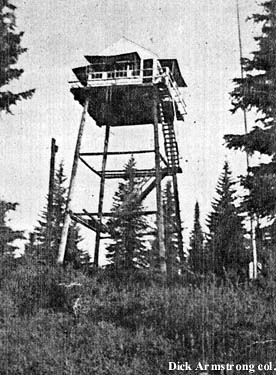
ARMSTRONG PEAKClearwater-Potlatch Timber Protective Assoc. - 40N-4E-13
|

|
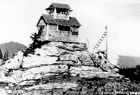
BALANCING ROCK
Clearwater National Forest - 39N-7E-22
|

|
BALD KNOBClearwater National Forest - 40N-8E-10
|

|
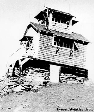
BALD MOUNTAINClearwater Timber Protective Assoc - 37N-4E-01
|

|
BAR POINTClearwater National Forest - 39N-8E-10
|

|
BEAR BUTTEClearwater National Forest - 38N-9E-17
|

|
BEAVER BUTTEClearwater Timber Protective Assoc - 40N-6E-10
|

|
BENTON BUTTEClearwater Timber Protective Assoc - 40N-5E-02
|

|
BERTHA HILLClearwater Timber Protective Assoc - 40N-5E-35
|

|
BIG HORN POINTClearwater National Forest - 38N-8E-21
|

|
BILLINGS (SUMMIT)
Clearwater Timber Protective Assoc - 38N-5E-35
|

|
BIRCH RIDGEClearwater National Forest - 41N-11E-30
|

|
BLACK MOUNTAINClearwater National Forest - 41N-7E-23
|

|
BLACKLEAD MOUNTAIN
Clearwater National Forest - 38N-13E-08
|

|
BM HILLClearwater National Forest - 38N-14E-10
|

|
BOEHLS BUTTEPotlatch Timber Protective Association - 41N-5E-30
|

|
BROWN CREEK #1Clearwater Timber Protective Association - 35N-5E-34
|

|
BROWN CREEK #2Clearwater Timber Protective Association - 34N-5E-3
|

|
BROWNS ROCKClearwater Timber Protective Association - 39N-6E-21
|

|
BRUIN HILLClearwater National Forest - 40N-12E-35
|

|
BUCK BUTTEClearwater Timber Protective Association - 38N-4E-32
|

|
CAVE POINTClearwater National Forest - 39N-7E-23
|

|
CHATEAU ROCKClearwater National Forest - 39N-8E-31
|
|
CLARKE MOUNTAINClearwater National Forest - 38N-7E-14
|

|
COLD SPRINGClearwater National Forest - 40N-9E-26
|
|
COOK MOUNTAINClearwater National Forest - 38N-9E-34
|

|
CROOKED FORKClearwater National Forest - 39N-14E-27
|
|
DAN LEE (DEWEY)Clearwater National Forest - 36N-6E-21
|
|
DEADHORSEClearwater Timber Protective Association - 39N-7E-7
|

|
DORIS POINTClearwater National Forest - 37N-8E-11
|
|
DULL AXEClearwater Timber Protective Association - 39N-5E-36
|

|
EAGLE POINTClearwater National Forest - 40N-7E-23
|

|
EAST ELKClearwater Timber Protective Association - 38N-7E-16
|
|
ELIZABETH MOUNTAINClearwater National Forest - 40N-10E-30
|
|
ELK BUTTEClearwater-Potlatch Timber Protective Association
40N-3E-5 |

|
ELK MOUNTAIN (ELK WEST)Clearwater Timber Protective Association - 38N-7E-07
|

|
FLY HILL CAMPClearwater National Forest - 41N-10E-31
|

|
FOURTH OF JULY
Clearwater National Forest - 39N-9E-32
|
|
FREEZEOUT TRAILClearwater Timber Protective Association - 41N-4E-21
|
|
FRENCH MOUNTAINClearwater National Forest - 37N-6E-33
|
|
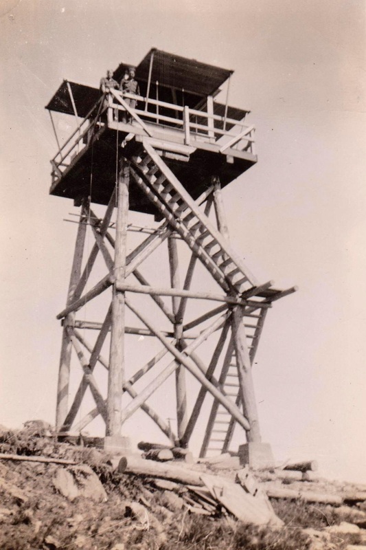
|
1949 - Courtesy of the Fire Lookout Museum
|

GOAT RIDGE (GRASSY)Clearwater Timber Protective Association - 41N-6E-12
|
|
|
1946 - Courtesy of the Fire Lookout Museum
|
1946 - Courtesy of the Fire Lookout Museum
|

GOAT RIDGE (PATROL)Clearwater Timber Protective Association - 41N-7E-19
|
|
GOLD BUTTEPotlatch Timber Protective Association - 40N-3E-35
|

|

GOOSE POINT
Clearwater National Forest - 41N-12E-28

GOOSE RIDGEClearwater National Forest - 41N-11E-24
|
|

GORMAN HILL
Clearwater National Forest - 39N-11E-22

GREEN MOUNTAINPotlatch Timber Protective Association - 40N-3E-02
|

|

GREEN POINT
Clearwater National Forest - 39N-8E-34

HEMLOCK BUTTEClearwater National Forest - 36N-7E-7
|

|

HEMLOCK BUTTE
Potlatch Timber Protective Association - 41N-2E-12
1960: "Extensive repairs were made to the lookout tower." (Potlatch Timber Protective Association Annual Report)

HORNET POINT
Clearwater National Forest - 41N-10E-28

HORSESHOE LAKEClearwater National Forest - 37N-11E-10
|

|
HUCKLEBERRY BUTTEClearwater Timber Protective Association - 37N-3E-19
|

|

INDEPENDENCE RIDGE
Clearwater National Forest - 40N-11E-33

ISABELLA POINTClearwater National Forest - 41N-7E-08
|
|

JACKSON MOUNTAIN
Potlatch Timber Protective Association - 40N-1E-12
1914: "However, a lookout has been established on Jackson's Mountain, in Sec. 11, Twp. 40 N., R. 1 E., on the divide between Ruby Creek and the East Fork of the Potlatch River." "We have a telephone on the Milwaukee Railroad on Ruby Creek, from which the lookout on Jackson's Mountain reports." (Annual Report of the Potlatch TPA)
1917: "A new telephone line was constructed from Potlatch Lumber Company's Camp Four, on Ruby Creek, to our Jackson Mountain Lookout, a distance of three and one-fourth miles." (Annual Report of the Potlatch TPA)

JERICHO MOUNTAINPotlatch Timber Protective Association - 39N-3E-17
|

|

JOHN LEWIS
Clearwater Timber Protective Association - 39N-4E-27
1915: "John Lewis Lookout Cabin......................(27-39-4E) $85.00." (9th Annual Report of the Clearwater TPA)

JOHNAGAN MOUNTAINClearwater National Forest - 37N-9E-30
|
|

JUNCTION MOUNTAIN
Clearwater National Forest - 39N-9E-25

KELLYS SISTERClearwater National Forest - 39N-13E-18
|
|

KELLYS THUMB
Clearwater National Forest - 39N-12E-22

LARCH BUTTEClearwater National Forest - 37N-7E-24
|
|

LARSON POINT
Clearwater National Forest - 39N-8E-08

LEAN-TO RIDGEClearwater National Forest - 37N-8E-28
|

|
LITTLE GREEN MOUNTAINClearwater Timber Protective Association - 39N-3E-09
|

|

LONG CREEK RIDGE
Clearwater National Forest - 41N-11E-16

LOOKOUT PEAKClearwater National Forest - 38N-10E-33
|
|

LOST RIDGE
Clearwater National Forest - 41N-8E-23

LUNDE PEAKClearwater National Forest - 38N-11E-23
|
|

MEADOW POINT
Clearwater National Forest - 41N-10E-12

MIDWAYClearwater National Forest - 39N-9E-17
|
|

MONROE BUTTE
Clearwater National Forest - 37N-10E-17

MOOSE MOUNTAIN (MODEL)Clearwater National Forest - 40N-10E-27
|
|

MOSCOW BAR
Clearwater National Forest - 40N-8E-25

MULLIKIN MOUNTAINClearwater Timber Protective Association - 38N-2E-29
|
|

MUSH POINT
Clearwater National Forest - 40N-8E-36

OROFINO CREEKClearwater TPA - 36N-4E-11
|

|
OSIER RIDGEClearwater National Forest - 40N-11E-12
|

|
POLLOCK HILLClearwater National Forest - 40N-12E-31
|
|
POT MOUNTAINClearwater National Forest - 39N-8E-11
|

|
RASPBERRY BUTTEClearwater National Forest - 38N-11E-31
|
|

RIVER
Clearwater Timber Protective Association - 39N-4E-28
1914: "Telephone line to be constructed from Headquarters, Section15-38-5 East, to the River Lookout, Section 28-39-4 East, of about 17 miles, as mapped out in 1912 Fire Warden's report for the season of 1913. We have sufficient wire and equipment on hand to build this line. It required the cutting of a new trail before constructing this line. We have completed the trail excepting three miles, which will be taken up at the opening of next season." (Clearwater TPA Annual Report)

SCOFIELD Clearwater Timber Protective Assoc - 38N-6E-04
|

|
SCURVY MOUNTAINClearwater National Forest - 39N-11E-30
|

|
SEVEN MILE POINTClearwater National Forest - 37N-8E-07
|
|

SHALE MOUNTAIN
Clearwater National Forest - 39N-13E-23
1930's: Camp

SHANGHAIClearwater Timber Protective Association - 37N-6E-07
|

|

SHEEP MOUNTAIN
Clearwater National Forest - 40N-7E-28
1914: Camp
1917: 20-foot pole platform with shake wall cabin built under tower.
1930: Log cabin and L-6 tower.
1950: Ruins

SHORT POINT
Clearwater National Forest - 41N-11E-12
1940: Camp

SILVER BUTTEClearwater Timber Protective Association - 39N-5E-22
|

|

SMITH POINT
Clearwater Timber Protective Association - 41N-6E-17
c.1934: 100-foot pole tower with L-6 cab and cabin.
1940's: Abandoned

SMITH RIDGE
Clearwater Timber Protective Association - 41N-5E-14
1918: 15-foot pole platform
1930's: Abandoned

SNEAK POINT
Clearwater National Forest - 40N-8E-18
1930's: Tower with L-4 cab
1941: Abandoned

STAR POINT
Clearwater National Forest - 38N-10E-16
1930's: Camp

STOCKING MEADOWSClearwater Timber Protective Association - 41N-4E-1
|

|

TAMARACK RIDGE
Clearwater National Forest - 37N-7E-05
1933: Pole tower with L-4 cab

THE NUBClearwater National Forest - 41N-8E-30
|
|
THOMPSON POINT
Clearwater Timber Protective Association - 41N-6E-33
c.1934: 40-foot pole platform, cabin at north end o fridge.
1958: Destroyed

TOBOGGAN HILL
Clearwater National Forest - 38N-12E-05
1930: 35-foot platform
1931: 2-story log crib L-4

TOBOGGAN RIDGE PATROL
Clearwater National Forest - 38N-12E-05
A crow's nest lookout point approximately one mile southeast of Toboggan Hill Lookout.

TOM HOWARD (MICKY)
Clearwater Timber Protective Association - 40N-6E-20
c.1934: Camp
1942: Abandoned

TOWNSHIP BUTTEClearwater Timber Protective Assoc - 39N-5E-06
|

|

TWIN PEAKS
Clearwater National Forest - 39N-10E-22
1934: Camp

UPPER BULL RUN
Potlatch Timber Protective Association - 39N-2E-05
c.1934: Camp

WALLOW MOUNTAINClearwater National Forest - 40N-8E-01
|

|
1932: L-4 cab
1968: 10-foot treated timber tower with a R-6 cab.

WEST SISTER (PATROL)
Clearwater National Forest - 41N-7E-27
|
1934 - Ron Kemnow Collection
|
An approximately 20-foot high round timber tower with enclosed cab (L-5 - L-6), used as a patrol lookout about one mile southwest of Black Mountain Lookout.

WHISKEY BUTTEClearwater Timber Protective Association - 37N-4E-05
|

|
ZELENKA
Clearwater Timber Protective Association - 37N-3E-04
|
|

Purple color text = "Fire Lookouts of the Northwest" by Ray Kresek (Lookout Inventory Revised 2015)
????
Potlatch Timber Protective Association - 40N-3E-11
1915: "A new lookout cabin was located and built in Sec. 11, Twp 42 N. R. 4 E., and a telephone line was built from Elk Butte to this cabin, a distance of 6 3/4 miles." (Potlatch Timber Protective Association Annual Report - 1915)
1915: "The patrol force was distributed in much the same manner as in 1914, except that three men were kept at Mason Meadow nearly all the time and three men were kept at the new cabin in Sec. 11, Twp., 40 N. R. 3 E., instead of two men which used to be kept at the old Green Mountain lookout." (Potlatch Timber Protective Association Annual Report - 1915)