IDAHO COUNTY (M-W)
MAGRUDER MOUNTAINBitterroot National Forest - 27N-13E-3
|

|
MAMMOUTH MOUNTAINNez Perce National Forest - 25N-8E-33
|

|
MAPLE LAKEClearwater National Forest - 34N-14E-18
|

|
MARBLE POINTNez Perce National Forest - 28N-4E-34
|

|
MARSHALL POINTPayette National Forest - 24N-5E-33
|

|
MAXWELL POINTPayette National Forest - 24N-5E-2
|

|
McCONNELL MOUNTAINClearwater National Forest - 35N-12E-23
|

|
MEADOW CREEKPayette National Forest - 29N-12E-30
|

|
MEEKER RIDGENez Perce National Forest - 32N-12E-7
|

|
MIDDLE BUTTEClearwater National Forest - 34N-8E-9
|

|
MINK POINTNez Perce National Forest - 31N-11E-11
|

|
MOCCASIN POINTNez Perce National Forest - 24N-7E-12
|

|
MOCUS POINTClearwater National Forest - 36N-11E-25
|

|
MOE PEAKNez Perce National Forest - 32N-15E-26
|

|
c.1921: camp
MOUNT AURABitterroot National Forest - 29N-13E-3
|

|
1930's: camp
MOUNT GEORGEBitterroot National Forest - 30N-15E-30
|

|
MOUNT HARRINGTONBitterroot National Forest - 25N-12E-1
|

|
c.1930: 60-foot pole tower with a 7x7 cab.
1940: 40-foot pole tower with L-4 cab.
1955: Destroyed

MUD CREEKClearwater National Forest - 33N-6E-4
|

|
MULE CREEK POINTPayette National Forest - 24N-12E-8
|

|
NELLIE MOUNTAINNez Perce National Forest - 29N-6E-21
|

|
1930's: camp
NELSON POINT (MILL CREEK)Payette National Forest - 23N-7E-10
|

|
NEZPERCE PEAKBitterroot National Forest - 28N-15E-27
|

|
NICK WYNN MOUNTAINBitterroot National Forest - 28N-14E-8
|

|
1940: L-4 cab
1955: destroyed

NIPPLE MOUNTAINNez Perce National Forest - 28N-7E-33
|

|
1931: 40-foot tower with L-6 cab, L-4 ground cab.
1968: destroyed

NOLAN POINT (KITCHEN RIDGE)Salmon National Forest - 23N-14E-36
|

|
NORTH POLENez Perce National Forest - 27N-6E-26
|

|
NUT BASINNez Perce National Forest - 25N-2E-11
|

|
O'HARA POINT
Nez Perce National Forest - 31N-8E-29
1935: 20-foot tower with L-4 cab
c.1955: destroyed

OLD MAN POINTClearwater National Forest - 34N-9E-20
|

|
OREGON BUTTENez Perce National Forest - 25N-6E-12
|
|
OTTER BUTTENez Perce National Forest - 31N-10E-11
|
|
c.1934: 30-foot tower with L-4 cab.
1955: destroyed

PARACHUTE RIDGE
Clearwater National Forest - 29N-12E-25
1934: camp

PETE FORK
Clearwater National Forest - 35N-7E-9

PETERSON POINT
St. Joe National Forest - 32N-7E-35
1937: camp
1941: abandoned

PETTIBONE RIDGENez Perce National Forest - 31N-14E-6
|

|
PILOT KNOBNez Perce National Forest - 30N-6E-28
|

|
PORTERS MOUNTAINNez Perce National Forest - 28N-8E-27
|

|
PROSPECT POINTNez Perce National Forest - 30N-10E-15
|
|
1930's: camp

PUZZLE POINTNez Perce National Forest - 30N-10E-15
|
|
QUARTZ RIDGENez Perce National Forest - 29N-4E-13
|

|
QUARTZITE BUTTE
Nez Perce National Forest - 25N-6E-8
1930: frame cupola cabin.
1940's: abandoned

RABBIT POINT
Nez Perce National Forest - 25N-9E-20
1930: log cupola cabin
c.1950: destroyed

RAINBOLD RIDGE
Nez Perce National Forest - 29N-5E-35
c.1930: camp
1940: abandoned

RAINY CREEK POINT
Nez Perce National Forest - 26N-11E-7
1939: camp

RAINY DAY POINT
Nez Perce National Forest - 28N-6E-15
c.1930: camp
1942: abandoned

RAMEY RIDGEPayette National Forest - 22N-10E-33
|

|
RANGER PEAK
Clearwater National Forest - 37N-16E-36
1960's: ?

RHODA POINT
Nez Perce National Forest - 34N-11E-16
1981: "The first time that this emergency lookout was ever manned was in 1937 when Ranger Millard Evenson was in charge of the district. That year William Pointer and a two man crew built a telephone line from End Butte out to Rhoda Point. The three men set their tent camp on the ridge near the point and on a boulder-strewn hilltop they built a 20-foot-high observation tower.
A short distance from the tower they built a cabin of peeled logs with a split cedar shake roof. The cabin was only about 8x10 feet in size and was primarily for off-season storage of camp equipment to avoid packing everything back to the ranger station or horse camp cabin. It was also used for sleeping quarters by the lookout man. Cooking was done under a tent and fly out front.
Daland Broker manned the point during the 1938-39 seasons. In 1938 he was given two helpers to build a telephone line on down to Doe Point, another emergency lookout. With the two men to help he also cleared the fire break around Rhoda Point tower and cabin. The lookout was manned through the 1941 season then dropped from the fire plan." (Louis Hartig, 'Historic Facilities of the Lochsa Ranger District' - 1981)

ROCK CREEK POINT
Nez Perce National Forest - 25N-4E-12
1939: camp
1951: abandoned

ROCK POINT
Nez Perce National Forest - 32N-15E-10
1930's: camp

ROCK RABBIT POINTPayette National Forest
|

|
ROCKY POINTPayette National Forest - 25N-11E-20
|

|
ROCKY POINTClearwater National Forest - 37N-14E-2
|

|
ROCKY RIDGE
Clearwater National Forest - 36N-8E-19

ROOTS KNOBPayette National Forest - 23N-12E-16
|

|
ROUND TOP MOUNTAINLolo > Clearwater National Forest - 37N-15E-20
|

|

ROUNDTOP
Nez Perce National Forest - 32N-9E-7
1930's: log cabin

SABE MOUNTAIN
Bitterroot National Forest - 27N-12E-23
1930's: tent camp
1949: abandoned

SABLE HILLNez Perce National Forest - 29N-10E-14
|
|
1933: 50-foot tower with L-4 cab.
c.1958: destroyed

1928: log cupola cabin.
1949: L-4 cab

SAVAGE RIDGE
Clearwater National Forest - 36N-16E-16
1929: 14x14 log cabin
1972: destroyed

SAWYER RIDGE
Nez Perce National Forest
1987: The lookout tower was sold as surplus property and was moved to a private location.

SCHOENFIELD RIDGE
Bitterroot National Forest - 29N-15E-35

SEABURG POINT
Nez Perce National Forest - 25N-3E-25
|
1925 - U.S. Forest Service
|

SHASTA POINT
Nez Perce National Forest

SHEARER PEAK
Nez Perce National Forest - 36N-13E-7

SHEEP HILLNez Perce National Forest - 26N-11E-15
|

|
SHEEPEATER MOUNTAINPayette National Forest - 24N-9E-27
|

|
SHISSLER PEAKNez Perce National Forest - 33N-12E-27
|

|
SILVER RIDGE
Nez Perce National Forest - 29N-5E-13

SIMMONS RIDGENez Perce National Forest - 29N-10E-8
|
|
SKOOKUM BUTTE
Clearwater National Forest - 38N-17E-1
SLATE POINTNez Perce National Forest - 26N-3E-7
|

|
SMITH BUTTE
Clearwater National Forest - 37N-9E-26

SMITH KNOB
Payette National Forest - 23N-8E-31
1958: A new R-6 cab was constructed on a cinder block base.
September 3, 2008: The removal of the lookout was completed. Due to the use of lead based paint the contract for removal required special treatment and the ensuing costs were $19,835.00.

SNOWY SUMMIT
Clearwater National Forest - 36N-7E-33

SODA CREEK POINT
Nez Perce National Forest - 28N-10E-33

SOURDOUGH PEAK
Nez Perce National Forest - 28N-5E-27
|
1928 - U.S. Forest Service
|

SPLIT CREEK POINT
Clearwater National Forest - 33N-9E-5
1931: A 30-foot timber tower with an L-4 cab constructed.
1934: The lookout was destroyed in the Pete King Fire and was never rebuilt.
1981: "Earl Bollman and Delbert Cox built a 30-foot tower on the ridge in 1931. In 1934, the structure was destroyed by fire and the point was dropped from the fire plan." (Louis Hartig, 'Historic Facilities of the Lochsa Ranger District' - 1981)

SPONGE MOUNTAIN
Clearwater National Forest - 34N-11E-29/30
1981: "Gold Meadows lookout was manned for the last time in 1938. The next year the tent camp was set up two miles south of Gold Meadows, at Sponge Mountain and that point was used for the observation station. Camp was near the Fish Lake Saddle-Mocus Point telephone line so a phone was tied in. Sponge Mtn. was manned through the 1941 season and then abandoned. No structures were ever built at this point." (Louis Hartig, 'Historic Facilities of the Lochsa Ranger District' - 1981)

SPOT MOUNTAINBitterroot National Forest - 28N-13E-4
|

|
SPREAD CREEK POINTNez Perce National Forest
|
|
SQUARE MOUNTAINNez Perce National Forest - 26N-5E-8
|
|
SQUAW PEAK (wahoo)Nez Perce National Forest - 33N-14E-36
|
|
STANLEY BUTTE
Clearwater National Forest - 34N-11E-33
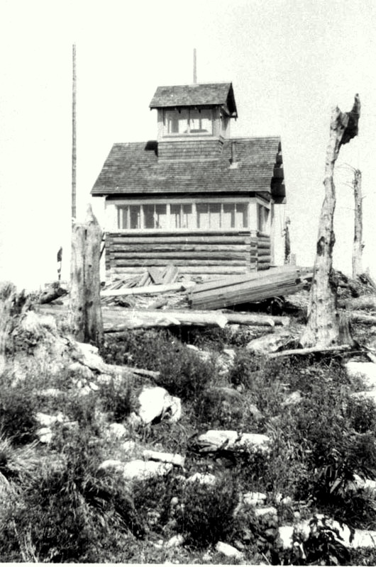
1981: "Stanley was manned as a lookout point for the first in 1921 when Marion Strine and an unidentified companion were moved up there and set up housekeeping in a tent camp. In 1922, fire guards, including lookout Strine, built a 12' x 14' log cabin about 200' NW from the mountain top.
A post on which to fit a Koch mapboard was wedged into the rock outcrop on the very top of the butte, in time a puncheon floor was laid around the post and a safety railing was installed. Lightning protection was added in the 1930's and later yet an Osborne firefinder replaced the Koch Board.
The cabin eventually acquired a hardwood floor, ceiling and walls covered with shiplap lumber. Also installed were mouse-proof cabinets for storage- no more mouse droppings in food and dishes.
In 1949 young Jim Mitchell manned the place for the last season. The cabin was condemned and burned in 1954."

STEAMBOAT PEAKPayette National Forest - 22N-6E-29
|

|
STEEP HILL
Bitterroot National Forest - 27N-16E-20

STILLMAN POINT
Nez Perce National Forest - 31N-8E-4

STODDARD CREEK POINTSalmon National Forest - 22N-14E-28
|

|
SWARTZ MEADOW
Nez Perce National Forest - 28N-3E-8

SWET LAKESalmon National Forest - 25N-13E-11
|

|
THREE CREEK PEAK
Payette National Forest - 23N-2W-4

THREE LINKS POINT
Nez Perce National Forest - 33N-11E-31

THREE PRONG MOUNTAIN
Nez Perce National Forest - 28N-12E-12

TONY POINTNez Perce National Forest - 32N-12E-33
|

|
TRAPPER TRAIL
Nez Perce National Forest - 31N-6E-17

TROUT PEAK
Nez Perce National Forest - 33N-13E-32

TWIN BUTTENez Perce National Forest - 32N-14E-35
|

|
UMBRELLA BUTTE
Nez Perce National Forest - 30N-15E-35

VAN CAMP
Clearwater National Forest - 34N-8E-32
1981: "Late in the 1925 fire season, Middlefork District Ranger Ray Ferguson sent firemen Earl Whitney and Russell Stadtman to Van Camp to man the point as a lookout for the remainder of the summer. The two men set their tent camp near a water supply in the first saddle north of Van Camp about 3/8 mile from the lookout point. They made regular morning and evening patrol trips to the point, except following lightning activity when more time was spent on lookout duty. When weather conditions permitted they brushed trail toward Middle Butte.
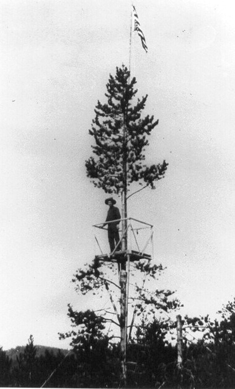
Van Camp is not a prominent point, it is flat topped and was at that time covered with scattered, low growing brush with no trees to obstruct the view. The men had no mapboard or lookout map, if a smoke was spotted a smokechaser map was oriented flat on the ground and an azimuth bearing taken with a pocket compass.
A photo taken in 1927 shows a lookout tree with a observation platform 50 feet or so above the ground."

VANCE POINTBitterroot National Forest - 30N-15E-35
|

|
VERMILLION PEAKNez Perce National Forest - 30N-11E-19
|
|
WALDE MOUNTAIN
Clearwater National Forest - 34N-7E-30
|
August 15, 2011 - Ron Kemnow photo
|
LQ - August 15, 2011 - Ron Kemnow photo
|
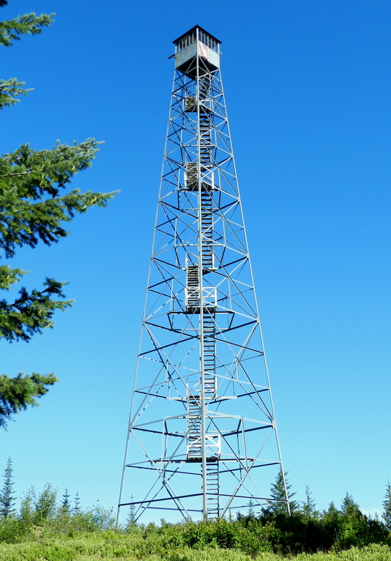
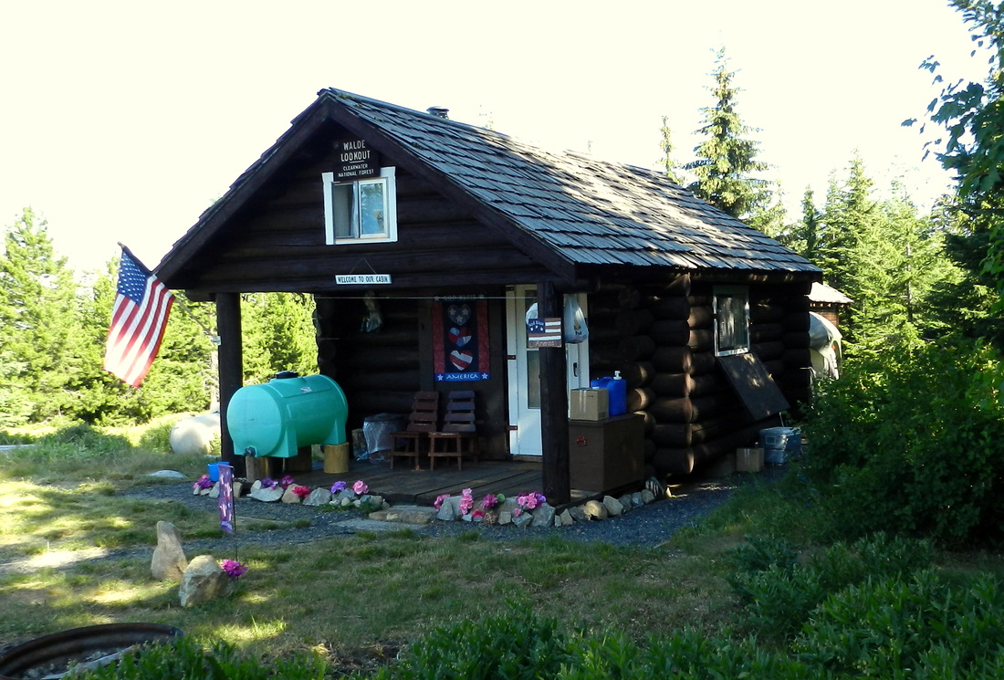
1981: "A 100' steel tower with a glass-enclosed observatory at the top was built on the mountain by the Nezperce National Forest in 1939 at a cost of $5143.00. Material for the structure was hauled in either by way of Suttler Creek or Glenwood to Mystery Saddle, then over a newly built shoo-fly road to the top of the mountain. In 1941, a 14'x16' well built log cabin with a shake covered roof, that projected 6' over a plank floored porch, was built for lookout living quarters by the same forest at a cost of $219.00. The new cabin was located only a few feet from the steel tower. The point was transferred from Middlefork District to Lochsa District by a boundary change in 1956.
The lookout was last manned in 1979 and was abandoned. The log cabin was condemned and burned in 1979, though the steel tower still stands." (Louis Hartig, 'Historic Facilities of the Lochsa Ranger District' - 1981)
WALL PEAK
Nez Perce National Forest

WAR EAGLEPayette National Forest - 23N-5E-24
|

|
WAUGH (LOST PACKER)
Bitterroot National Forest - 25N-14E-19

WEASEL POINTNez Prece National Forest - 32N-11E-34
|

|
WEITAS BUTTEClearwater National Forest - 36N-8E-10
|

|
WENDOVER RIDGE
Clearwater National Forest - 37N-13E-15

WEST FORK POINT
Nez Perce National Forest - 31N-7E-23

WHITE SAND
Clearwater National Forest - 36N-16E-23

WILLOW RIDGE
Clearwater National Forest - 35N-8E-13
1981: "The point is located at the end of Trail #237, going in by way of Fish Creek. It was used as a lookout for the first time in 1929 when Ranger Ralph Hand, who was putting in his last season on Lochsa District, set a tent camp and one man on the ridge. For communication a telephone line was strung in from Obia cabin.
By 1930 Ranger Fred Shaner had taken over the District and under his direction, a pre-cut, L-4 lookout cabin was packed to the ridge and Earnest Hartman with Harry Chenoweth went up and put it together. It was built on log sills flat on the ground, no understory or tower. The station was manned each season until 1934 when the big fire reduced the cabin to ashes. Willow Ridge was never manned again, mainly due to the lack of anything to protect." (Louis Hartig, 'Historic Facilities of the Lochsa Ranger District' - 1981)

WITTER RIDGE
Bitterroot National Forest - 26N-13E-26

WOLF POINTNez Perce National Forest - 32N-11E-33
|

|
WOOD HUMPBitterroot National Forest - 26N-14E-36
|

|
WOODRAT MOUNTAINClearwater National Forest - 33N-5E-24
|

|
WOUNDED DOE RIDGEClearwater National Forest - 34N-11E-12
|

|
WYLIES PEAKNez Perce National Forest - 31N-12E-33
|

|