SHOSHONE COUNTY
ADAMS PEAKSt. Joe National Forest - 45N-7E-13
|

|
AGATHA CREEKSt. Joe National Forest - 46N-3E-34
|

|
ANTHONY PEAKSt. Joe National Forest - 42N-2E-15
|

|
*ARID PEAK
St. Joe National Forest - 46N-5E-1
|

|
AVERY HILLSt. Joe National Forest - 45N-5E-4
|

|
BAD TOMSt Joe National Forest - 47N-4E-15
|

|
BALD MOUNTAINSt Joe National Forest - 47N-7E-31
|

|
BATHTUB MOUNTAINSt Joe National Forest - 43N-7E-10
|

|
BEARSKULLSt Joe National Forest - 44N-6E-34
|

|
BEAVER PEAKCouer d' Alene National Forest - 54N-2E-35
|

|

BEAVER PEAKSt. Joe National Forest - 43N-8E-23
|

|

BEETLE HUMPSt Joe National Forest - 45N-8E-23
|

|

BERGE PEAK (PATROL LO)St Joe National Forest - 45N-9E-33
|

|

BERNIER POINTSt Joe National Forest - 46N-7E-27
|

|

BIG CREEKSt Joe National Forest - 46N-3E-16
|

|

BIG DICK POINTSt Joe National Forest - 46N-6E-20
|

|

BINOCULAR POINTSt Joe National Forest - 43N-10E-2
|

|

BLACK PEAKSt Joe National Forest - 44N-9E-1
|

|

BLACK PEAK

BLACKJACK PEAKSt Joe National Forest - 45N-8E-27
|

|

BLOOM PEAK
Coeur d'Alene National Forest - 51N-5W-21
1932: L-4 cab
1943: Abandoned

BLUEBIRD POINT
St Joe National Forest - 46N-7E-30
c.1925: camp
1930's: L-4 cab
1969: Destroyed

BLUFF (DOMINION)
St. Joe National Forest - 44N-7E-12
1935: L-4 cab
1956: gone

BOBTAIL PEAK
Coeur d'Alene National Forest - 50N-5E-6
1934: 30-foot pole tower with L-4 cab
c.1955: Destroyed

BOGUS POINT
St Joe National Forest - 45N-1E-27
1939: camp
1940's: Abandoned

BREEZY POINT (PATROL LO)
St Joe National Forest - 44N-4E-34

BRUSH HILL (PATROL LO)
National Forest
15-foot tower with L-6 cab

BUMBLEBEE PEAKCoeur d'Alene National Forest - 50N-1E-15
|

|

BUSSEL PEAK
St Joe National Forest - 44N-3E-19
1938: 30-foot pole tower with L-4 cab
1958: Destroyed

BUZZARD ROOST
St Joe National Forest - 42N-6E-14
1919: camp
1935: L-4 cab
1954: Destroyed

CABIN PEAK (SPUR)
Coeur d'Alene National Forest

CALUSA POINT
Couer d'Alene National Forest - 47N-2E-18
1930's: crow's-nest

CAMERON HILL (PATROL LO)
St. Joe National Forest

CANYON PEAK (PATROL LO)
St Joe National Forest - 42N-2W-6

CAPITAL HILL
Coeur d'Alene National Forest - 49N-4E-29
c.1930: camp
c.1936: 40-foot pole tower with L-4 cab
1960: Destroyed

CASCADE POINT
St Joe National Forest - 43N-10E-22
1935: 20-foot pole tower with L-4 cab
1961: gone

CATHEDRAL PEAK
Coeur d'Alene National Forest - 53N-3E-8
1931: 30-foot pole tower with L-4 cab. two patrol lookout points
1955: Destroyed

CEDAR MOUNTAINSt. Joe National Forest - 46N-5E-16
|

|

CEMETERY RIDGESt Joe National Forest - 47N-3E-35
|

|

CHARACTER PEAK
National Forest - 49N-3E-2
1932: camp with crow's-nest
1947: Abandoned

CHICKADEE (BRUSH)
St. Joe National Forest - 42N-6E-8
1915: cabin

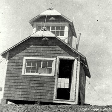
CLARKIA PEAK
St. Joe National Forest - 42N-1E-1
|
no date - Courtesy of the Fire Lookout Museum
|
1936: 30-foot pole tower with L-4 cab
1962: Destroyed

CLUB POINT
St. Joe National Forest - 43N-8E-35
1935: L-4 cab
1953: Abandoned

CODDINGTON PEAK
St. Joe National Forest - 44N-2E-10
1930's: camp

CONRAD PEAKSt. Joe National Forest - 44N-8E-16
|

|

CORNWALL POINT
St. Joe National Forest - 43N-3E-10
1939: camp
1942: Abandoned

COUGAR PEAKCoeur d'Alene National Forest - 50N-2E-16
|

|

CRADDOCK PEAK
St Joe National Forest - 45N-8E-6
1936: camp
1940's: Abandoned

CRITTENDON PEAK
St Joe National Forest - 46N-7E-15
1930's: L-4 cab
1962: Destroyed

CRYSTAL PEAK
St. Joe National Forest - 44N-1E-23
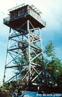 1985 - Ray Kresek photo
|
1930: crow's-nest
1954: 41-foot treated timber tower with L-4 cab

DAM RIDGE
St. Joe National Forest - 47N-4E-20
1928: log cabin
1934: tower with L-4 cab
1954: Destroyed

DAVEGGIO KNOB
St. Joe National Forest - 44N-3E-1
1939: camp
1942: L-4 cab
1963: Destroyed

DEVIL PEAK
Coeur d'Alene National Forest - 53N-2E-17
1931: camp
1934: L-4 cab
1947: Destroyed

DIVIDE PEAK
Coeur d'Alene National Forest - 53N-3E-2
1931: 30-foot pole tower with L-4 cab
c.1950: gone

DOMINION MOUNTAIN (See Mineral County, Montana)
St Joe National Forest - 46N-7E-4
July 26, 1933: “Charles Nelson has been placed on Dominion Peak on the State Line at the head of Silver Creek south of Saltese as Lookout and Patrolman. The new road constructed in 1932 along the Montana-Idaho Divide will be used by him on his patrol work.” (The Sanders County Independent-Ledger)

DOMINION POINT (PATROL LO)
St. Joe National Forest

DOWNEY PEAK
Coeur d'Alene National Forest
crow's-nest

DUNN PEAK (STORM) |

|
St. Joe National Forest - 46N-4E-36

EARLY RIDGE (PATROL LO)
National Forest

EAST GROUSE
Coeur d'Alene National Forest

1935: Company 531 at Camp F-132 (Big Creek) of the Civilian Conservation Corps completed the construction of a 20-foot round native timber tower with an L-4 cab.
c.1950: gone

EIGHTY PEAK
Coeur d'Alene National Forest - 52N-4E-4
1920: stone shelter
1928: cupola cabin
1955: gone

EIGHTY-ONE POINT
St. Joe National Forest - 45N-7E-2
1930's: camp

ELK RIDGE
St. Joe National Forest - 46N-3E-31
1930's: camp

ELSIE PEAK
St. Joe National Forest - 47N-3E-29
1921: log cabin, crow's-nest
1931: tower
1954: Destroyed

FISHHOOK PEAK
St. Joe National Forest - 44N-4E-21
1922: 10-foot pole tower with a metal cupola.
1925: log cabin
1931: 20-foot pole tower with L-4 cab
1969: Destroyed

FITZGERALD PEAK
St. Joe National Forest - 46N-2E-7
1934: camp
1938: tower with L-4 cab
1952: Destroyed

FIVE LAKES BUTTE
St. Joe National Forest - 42N-9E-25
1934: camp

FLASH PEAKSt. Joe National Forest - 46N-5E-30
|

|

FREEZEOUT RIDGEPotlatch Timber Protective Association - 42N-3E-12
|

|

GETAWAY POINT
St. Joe National Forest - 42N-6E-32
1939: pole tower, tent camp
1940's: Abandoned

GIBSON POINT
St. Joe National Forest - 47N-5E-32
|
no date - Courtesy of the Fire Lookout Museum
|
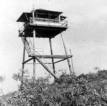
1933: 30-foot pole tower with L-4 cab
1953: Abandoned

GNAT PEAK
St. Joe National Forest - 42N-7E-29
1939: camp

GOAT MOUNTAIN
St. Joe National Forest - 42N-5E-9
1916: crow's-nest, cabin
1934: 50-foot pole tower with L-4 cab
1961: Destroyed

GOLD HILL
National Forest - 47N-5E-9
1938: 50-foot pole tower with L-4 cab
1948: Abandoned

GOSPEL HILL
Clearwater National Forest - 42N-10E-21
1934: pole tower
July 28, 1939: "Bill Hyland, forest service lookout at Gospel mountain, near Montana-Idaho line, chopped off the first joint of his finger while cutting wood. He rode 25 miles on horseback to reach a car sent from here. The trip took 24 hours. He was treated at Orofino hospital." (Spokane Daily Chronicle)

GRAHAM MOUNTAIN
Coeur d'Alene National Forest - 49N-3E-7
1922: log cabin, windmill tower with platform
June 27, 1930: "Forest Ranger T.R. Peterson, stationed on top of Granham Peak as fire lookout and his partner, Eric Swanson, smoke chaser, had a merry time of it early in the week during severe electrical storms in this district.
One bolt of lightning took the tower off the lookout station, split the roof and played havoc with the entire structure, it was learned here today. The rangers escaped injury but do not care for a repetition of the experience.
The storm started five fires which were spotted from the station." (Spokane Daily Chronicle)
July 28, 1931: "Construction of a new tower and observatory on Graham peak was completed yesterday by forest service employes, Ed F. Helmers, senior forest ranger, reported last night. The lookout is one of the most modern in the northwest and gives a greater visibility than any other station in the Coeur d'Alene national forest.
Mounted on a 60-foot tower atop of the Coeur d'Alene district's highest peaks, the 7x7 foot observatory is entirely enclosed with glass, allowing visibility in all directions. Included in the equipment is a new Bosworth lookout board, all metal and circular, replacing the old wooden, square type. Modern lightning protection equipment has been installed and a 'dispatcher's head-set' telephone in use. Five flights of steps, each 14 feet long, lead to the observatory, which is securely anchored by four guide lines. Tilmer Peterson is the lookout in charge." (Spokane Daily Chronicle)
c.1933: 60-foot patrol tower with L-6 cab added.
1955: Destroyed

GRANDMOTHER MOUNTAINSt. Joe National Forest - 43N-3E-27
|

|

GRANITE PEAK
National Forest - 49N-5E-25

GRASSY MOUNTAINCoeur d'Alene National Forest - 51N-2E-9
|

|

GRAYS PEAK (PATROL LO)
St. Joe National Forest

GRIFFITH PEAK
Coeur d'Alene National Forest - 53N-1E-25
1934: 30-foot pole tower with L-4 cab
October 7, 1945: "Another teenager on the job is Leonine Garnett, 18, who is up on Griffith Peak, 5,800 feet, and 60 miles from Coeur d'Alene." (La Crosse Tribune)
1953: Destroyed

GRIZZLY MOUNTAINCoeur d'Alene National Forest - 50N-3E-4
|

|

GUARD PEAK
Coeur d'Alene National Forest
1919: A frame cabin with a platform on the roof.
For later structures see Little Guard Peak.

HALFWAY PEAK
Coeur d'Alene National Forest - 51N-2E-24
1931: L-4 cab
1942: Abandoned

HAYSTACK MOUNTAIN
Coeur d'Alene National Forest - 51N-4E-21
1932: crow's-nest
1947: Abandoned

HILL 36
National Forest - 46N-3E-36
1930: crow's-nest
1934: 10-foot pole tower with L-4 cab
1958: Destroyed

HOMESTEAD HUMP
St. Joe National Forest - 44N-3E-36
1930's: camp
1940's: Abandoned

HONEY JONES PEAK
St. Joe National Forest - 46N-1E-10
1930's: crow's-nest

HORSESHOE PEAK
National Forest - 50N-5E-28
1939: crow's-nest
1947: Abandoned

HOYT MOUNTAINSt. Joe National Forest - 45N-4E-26
|

|
HUCKLEBERRY MOUNTAINSt. Joe National Forest - 45N-2E-36
|

|
HULLIMAN PEAKCoeur d'Alene National Forest - 52N-4E-26
|
|

IDAHO POINT
Coeur d'Alene National Forest - 52N-4E-4
1934: 20-foot pole tower with L-4 cab
1971: Destroyed

INCLINE RIDGESt. Joe National Forest - 43N-2E-4
|

|

INDIAN DIP (JOKER)
St. Joe National Forest - 42N-6E-20
c.1927: camp
1931: L-4 cab
1957: Destroyed

JUG ROCK
St. Joe National Forest - 42N-5E-3
c.1915: log cabin
1919: platform tower
1939: tower with L-4 cab
1954: gone

KELLOGG PEAKNational Forest > Silver Mountain Ski Resort - 48N-3E-19
|

|

KELLY PINNACLE
St. Joe National Forest - 46N-6E-1
1936: camp
1940: Abandoned

KINGS PASS
Coeur d'Alene National Forest - 50N-4E-33
1934: 40-foot pole tower with L-4 cab
1950's: Destroyed

LARCH MOUNTAIN
Coeur d'Alene National Forest - 54N-1E-24
1934: 30-foot pole tower with L-4 cab
1955: Destroyed

LEMONADE PEAK
St. Joe National Forest - 47N-2E-34
1934: L-4
1962: R-6 cab atop 10-foot concrete lower floor
1973: Abandoned

LICK POINT
St. Joe National Forest - 44N-5E-8
1934: 50-foot pole tower with L-4 cab
1951: Destroyed

LINDROOS HILL
National Forest - 48N-5E-36
1933: 30-foot pole tower with L-4 cab
June 17, 1953: "The Lindroos Hill lookout station east of Mullan will not be used this year, Forest Ranger J. E. Sanderson reports. He said the station will be dismantled because it is becoming unsafe but that the picnic area surrounding the site will be cleaned and enlarged for public use.
The lookout station, a landmark, had deteriorated from long use and also had been damaged by vandals, Sanderson said." (The Spokesman-Review)
1955: Destroyed

LINFOR HILL
Coeur d'Alene National Forest - 49N-2E-15
1934: 30-foot pole tower with L-4 cab
1950: gone

LITTLE BALDY
Coeur d'Alene National Forest - 50N-5E-8
1920: camp
1922: log cabin with cupola
1940: 20-foot pole tower with L-4 cab
1970: Destroyed

LITTLE GUARD PEAKCoeur d'Alene National Forest - 51N-4E-6
|
|
LITTLE JOE MOUNTAINSt. Joe National Forest - 44N-10E-18
|

|
c.1924: camp
1930: 14x14 log cabin
1953: Destroyed

LONG LIZ POINT
St. Joe National Forest - 46N-6E-15
1934: camp

LOOKOUT MOUNTAIN
St. Joe National Forest - 43N-4E-9
1934: 10-foot pole tower with L-4 cab
1970: Abandoned

MAGEE PEAK
National Forest - 52N-1E-2
1930's: camp

MALLARD PEAK |

|
St Joe National Forest - 42N-7E-36

MAPLE PEAK
Coeur d'Alene National Forest - 50N-5E-36
1938: L-4 cab
1950: gone (moved to Sunset LO)

MARBLE MOUNTAIN
Coeur d'Alene Timber Protective Association - 44N-3E-24
1920: camp
1923: "We are using the old look-out system and I still think it efficient, if we had control of all our lookout stations. Marble Mountain was taken over by the U.S. Forest Service in the spring of 1923. They fixed it up and made a modern station out of it. We have received very little benefit from it since." (Annual Report of the Coeur d'Alene TPA)
December 22, 1928: "Because Clair Corey, 19-year-old fire lookout for the Coeur d'Alene Timber Protective association was on top of a mountain when killed by lightning his parents are entitled to compensation, the state industrial accident board decided Friday.
The award for the death followed decision denying award to the widows and children of two men killed by lightning in valley section. In the case of the two men, it was ruled, their work did not increase the hazard of being struck by lightning. In the case of Corey, his location on Marble mountain in Shoshone county, increased the hazard, the board ruled." (The Salt Lake Tribune)
The award for the death followed decision denying award to the widows and children of two men killed by lightning in valley section. In the case of the two men, it was ruled, their work did not increase the hazard of being struck by lightning. In the case of Corey, his location on Marble mountain in Shoshone county, increased the hazard, the board ruled." (The Salt Lake Tribune)
1939: tower with L-4 cab

MARCUS COOK (PATROL LO)
National Forest

MARTIN PEAK (PATROL LO)
National Forest

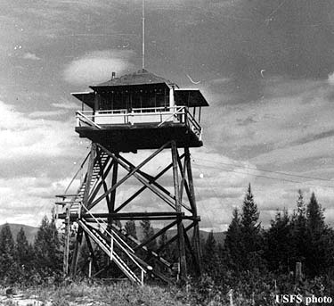
MASTADON MOUNTAIN
St. Joe National Forest - 46N-4E-4
|
1936 - Courtesy of the Fire Lookout Museum
|
1926: camp
1929: cupola cabin
1963: R-6 cab atop a 10-foot concrete first floor
1980's: Destroyed

MATERNITY RIDGE
St. Joe National Forest - 45N-3E-7
1930's: camp

McDONALD PEAKCoeur d'Alene National Forest - 51N-1E-24
|

|

MIDDLE SISTER PEAK |

|
St. Joe National Forest - 44N-6E-12

MIDGET
St. Joe National Forest - 44N-9E-29
1929: platform tower, cabin
1942: Abandoned

MONUMENTAL BUTTE
St. Joe National Forest - 42N-5E-3
|
1924 - Courtesy of the Fire Lookout Museum
|
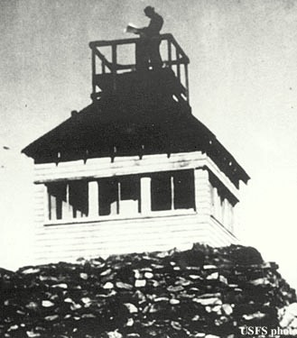
c.1919: log cabin
1921: burned
1922: 13x13 frame cabin with roof platform
1924: destroyed by lightning
1925: cupola cabin
October 1, 1933: "The lookout house on Monumental Buttes, St. Joe national forest, after lightning had surged in over the telephone line. The cabin was shattered, but the lookout man escaped injury. The telephone line was melted and 'spattered like sourdough batter over the rocks.' according to the report of the then ranger, Franklin Girard, who is now secretary of state of Idaho." (The Spokesman Review) Occurred in July 1933
1969: Destroyed

MOON PEAK
St. Joe National Forest - 47N-5E-19
1931: camp

MOWAT
St. Joe National Forest - 46N-3E-14
1934: camp

MULLIGAN HUMP
St. Joe National Forest - 42N-6E-13
1930"s: crow's-nest

MURRAY PEAK
Coeur d"Alene National Forest
crow's-nest

NEEDLE PEAK
St. Joe National Forest - 43N-9E-36
1935: tower with L-4 cab
1957: Destroyed

NELSON PEAK
St. Joe National Forest - 45N-6E-4
1920's: log cupola cabin
1935: 48-foot pole platform on west summit
1939: tower with L-4 cab on east summit
1969: Destroyed

NIRA POINT
Coeur d'Alene National Forest
patrol lookout with crow's-nest

NORTH BUTTE
St. Joe National Forest - 43N-5E-26
1932: 10-foot pole tower with L-4 cab
1969: Destroyed

NORTH SNOW PEAKCoeur d'Alene National Forest - 53N-1E-12
|

|

NUGGET HILL
St. Joe National Forest - 45N-7E-22
1935: camp
1940's: Abandoned

NUGGET RIDGE
St. Joe National Forest - 44N-7E-6
1922: crow's-nest, cabin

O'NEILL HILL (PATROL LO)
National Forest

ORPHAN POINT
St. Joe National Forest - 43N-4E-27
1939: camp
1942: tower with L-4 cab
1954: Destroyed

PACKSACK POINT
Coeur d'Alene National Forest - 52N-2E-12
1930's: crow's-nest, camp

PAPOOSE
National Forest - 43N-7E-25
1930: pole platform
1938: tower with L-4 cab

PEGGY PEAK
National Forest - 43N-8E-8
1926: alidade
1934: L-4 cab

PEGLEG POINT
National Forest - 44N-9E-22
1934: tower with L-4 cab
1952: Destroyed

PINCHOT BUTTE
National Forest - 42N-4E-10
1939: camp

PINE POINTCoeur d'Alene National Forest - 48N-2E-16
|

|

PINEAPPLE PEAK (PATROL LO)
St. Joe National Forest

POCONO HILL
National Forest - 45N-3E-22
1930's: camp

POINT EIGHTY-ONE

POLARIS PEAKCoeur d'Alene National Forest - 48N-3E-26
|

|

POLE MOUNTAIN
National Forest - 42N-8E-15
1921: log cabin
1930: cupola cabin

POND PEAK
Coeur d'Alene National Forest - 52N-3E-14
1929: camp
1932: L-4 cab
1960: Destroyed

PRITCHARD PEAK
Coeur d'Alene National Forest - 50N-4E-22
1939: crow's-nest, camp
1941: Abandoned

PULASKICoeur d' Alene National Forest - 48N-4E-33
|

|
QUARLES PEAK
St. Joe National Forest - 46N-7E-35
|
|

RED IVES PEAK
National Forest - 43N-9E-23
1935: fire finder
1940's: Abandoned

RENFRO
National Forest - 44N-1E-2
1940: camp

ROUNDTOP MOUNTAIN
National Forest - 44N-5E-33
1922: 50-foot pole tower with 7x7 cab
c.1927: 45-foot steel windmill tower with 6x6 cab
1952: 53-foot treated timber tower with L-4 cab
1979: Destroyed

RUBY POINT
National Forest - 42N-9E-20

RUNT MOUNTAIN
National Forest - 47N-6E-4

SAWTOOTH PEAK
National Forest - 42N-7E-9

SHEEP DRIVE POINT
National Forest - 46N-3E-23

SHEFOOT MOUNTAIN
St. Joe National Forest - 46N-6E-27
1931: L-4 cab
1961: Destroyed

SHOSHONE PEAK
Coeur d'Alene National Forest - 53N-3E-35
1931: 40-foot pole tower with L-4 cab (burned in 1931)

SILVER HILL
National Forest - 47N-3E-6

SIMMONS RIDGE
National Forest - 43N-9E-12

SISTERS BASIN
National Forest - 44N-6E-21

SIWASH PEAK
National Forest - 45N-6E-31

SNOW PEAKSt. Joe National Forest - 43N-7E-30
|

|

SPION KOP
Coeur d'Alene National Forest - 53N-3E-33
1934: 30-foot pole tower with L-4 cab (also patrol LO one mile SW)
1955: gone

SPOOKY BUTTE
National Forest - 46N-2E-13

SPRUCE DIVIDE
Coeur d'Alene National Forest - 57N-6W-25

SPYGLASS PEAKCoeur d'Alene National Forest - 52N-2E-22
|

|

STATE LINE
National Forest - 45N-8E-12

STEAMBOAT PEAK
Coeur d'Alene National Forest - 51N-2E-33
1930: camp
1934: 40-foot pole tower with L-4 cab
1950's: Destroyed

STEVENS PEAK
National Forest - 47N-5E-13

STONY CREEK
Potatch Timber Protective Association - 42N-3E-19

STRIPED PEAKNational Forest - 47N-4E-7
|

|

STUBTOE PEAK
National Forest - 43N-6E-34

SUBURBAN PEAK
Coeur d'Alene National Forest - 52N-3E-31
1931: crow's-nest
c.1934: 50-foot pole tower with L-4 cab
c.1952: gone

SUNSET PEAKCoeur d'Alene National Forest - 49N-5E-31
|

|

SURVEYOR'S RIDGESt. Joe National Forest - 42N-7E-11
|

|

SWAN PEAK
National Forest - 44N-2E-36

TAYLOR PEAKCoeur d'Alene National Forest - 51N-4E-1
|
|

TEEPEE SUMMIT
Coeur d'Alene National Forest - 51N-1E-23
1933: log cabin
1934: 30-foot pole tower with L-6 cab
c.1950: gone

THOMAS HILL
Coeur d'Alene National Forest
20-foot platform tower

THOR MOUNTAIN
National Forest - 44N-7E-15

TREGO (PATROL LO)
Coeur d'Alene National Forest

TURKEY POINT (PATROL LO)
St. Joe National Forest

TURNER PEAK
National Forest - 45N-6E-1

TYLERS RIDGE
National Forest - 44N-2E-20

URANUS PEAK
Coeur d'Alene National Forest - 50N-3E-1
1931: 40-foot pole tower with L-4 cab
c.1950: Destroyed

VANDERBILT HILL
National Forest - 42N-11E-31

WALO POINT
National Forest - 44N-8E-27

WARD PEAK
National Forest - 45N-8E-12

WASHOUT POINT
National Forest - 44N-10E-32

WEST ELK PEAK
National Forest - 43N-1E-12

WHITE PEAKCoeur d'Alene National Forest - 49N-3E-12
|
|

WHITETAIL PEAK
Coeur d'Alene National Forest - 54N-2E-24
1934: 50-foot pole tower with L-6 cab
1953: Abandoned

WINDFALL PEAK
Coeur d'Alene National Forest - 54N-2E-32
c.1934: 50-foot pole tower with L-4 cab
1952: Destroyed

WONDERFUL PEAK
National Forest - 47N-5E-24

YANKEE PEAK
National Forest - 42N-10E-3